
SKU: DJIEMAT4ENUK1Y
DJI MATRICE 4 ENTERPRISE (M4E) UK PLUS COMBO
DJI MATRICE 4 ENTERPRISE (M4E) UK PLUS COMBO
Couldn't load pickup availability
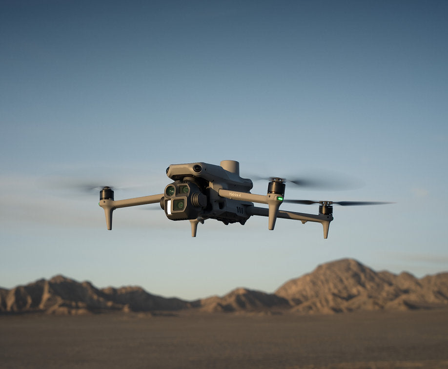
DJI Matrice 4 Enterprise is a compact survey-grade mapping drone, replacing the Mavic 3 Enterprise in geospatial workflows. With integrated RTK, 3-directional ortho capture and a 49-minute flight time, it is built for surveying, construction, mining and 3D modelling.
Full Description
Full Description
DJI Matrice 4 Enterprise is a compact survey-grade mapping drone, replacing the Mavic 3 Enterprise in geospatial workflows.
With integrated RTK, 3-directional ortho capture and a 49-minute flight time, it is built for surveying, construction, mining and 3D modelling.
-
C2 marked - ready for flight in the Open A2 'Near people' category with an A2 CofC qualification.
-
Don't forget to add extras, such as additional flight batteries; RC Plus 2 strap, the D-RTK 3 for high-precision positioning and relay or the AL1 Spotlight / AS1 Speaker which can be used separately or together.
-
Training - Receive support from our in-house instructor team. All our training is face-to-face - tuition for individuals or organisations training multiple remote pilots.
-
Dedicated Survey Assistance - our DJI Certified Solutions team and survey trained and experienced team for wrap around hardware/software assistance. The DJI M4E also comes with a free one year DJI Terra licence.
-
DJI Care Enterprise (Plus) cover for one year, enabling an unlimited number of repairs within the coverage period (Subject to DJI T&C's)
-
ASG Support is included, providing a range of complementary services. For a wider support package, tailored to complex operations, choose the Managed Service option.
-
ASG's highly experienced team is here to support you, covering maintenance and equipment support, training, DJI Certified Delivery and Solutions engineers, SORA / regulatory consultancy.
In The Box
In The Box
- DJI Matrice 4 Enterprise M4E x1
- DJI Matrice 4 Series Hard-Case x1
- DJI RC Plus 2 Remote Contoller x1
- DJI 100W USB-C Power Adapter x1
- DJI Matrice 4 Series Charging Hub x1
- Micro SD card (64Gb) x1
- DJI Matrice 4T Gimbal protector x1
- DJI Cellular Dongle 2 Pry bar x1
- DJI Matrice 4 Series Propellers (Pairs) x3
- 100W Power adaptor AC cable x1
- USB-C to USB-C data cable x1
- USB-A to USB-A data cable x1
- DJI Matrice 4 Series hard case shoulder strap x1
*Please note, that the WB37 remote controller battery needs to be purchased separately.
Aircraft Specifications
Aircraft Specifications
- Takeoff Weight (with Low-Noise propellers) - 1229 g
- Max Takeoff Weight - Low-Noise Propellers: 1430 g
- DimensionsFolded: 260.6×113.7×138.4 mm (L×W×H)Unfolded: 307.0×387.5×149.5 mm (L×W×H)Maximum dimensions excluding propellers.
- Max Ascent Speed - 10 m/s
- Maximum Ascent Speed With Accessories -6 m/s
- Max Descent Speed - 8 m/s
- Max Descent Speed With Accessories - 6 m/s
- Max Horizontal Speed (at sea level, no wind) - 21 m/s21 m/s flying forward, 18 m/s flying backward, 19 m/s flying sideways
- Max Altitude - 6000 m
- Max Operating Altitude with Payload - 4000 m
- Max Flight Time (without wind)46 min (low-noise propellers)
- Max Hover Time (without wind)39 min (low-noise propellers)
- Max Flight Distance (no wind)32 km (low-noise propellers)
- Max Wind Speed Resistance12 m/s
- Max Pitch Angle35°
- Operating Temperature-10℃ to 40℃ (14°F to 104°F)
- GNSSGPS + Galileo + BeiDou + GLONASS
- Hovering Accuracy Range (windless or breezy)
- ±0.1 m (with Vision System); ±0.5 m (with GNSS); ±0.1 m (with RTK)
- RTK GNSS Accuracy
- RTK Fix:1 cm + 1 ppm (horizontal), 1.5 cm + 1 ppm (vertical)
- 1154F (low noise propeller)
- BeaconBuilt into the aircraft
Payload Specifications
Payload Specifications
Image Sensor
- Wide: 4/3-inch CMOS, Effective Pixels: 20 MP
- Medium Tele Camera: 1/1.3-inch CMOS, Effective Pixels: 48 MP
- Telephoto: 1/1.5-inch CMOS, Effective Pixels: 48 MP
Wide Lens
- FOV: 84°
- Equivalent Focal Length: 24 mm
- Aperture: f/2.8-f/11
- Focus: 1 m to ∞
Medium Tele Camera
- FOV: 35°
- Equivalent Focal Length: 70 mm
- Aperture: f/2.8
- Focus: 3 m to ∞
Tele Camera
- FOV: 15°
- Equivalent Focal Length: 168 mm
- Aperture: f/2.8Focus: 3 m to ∞
ISO Range Normal Mode: ISO 100 to ISO 25600
Night Scene Mode
- Wide Camera: ISO 100 to ISO 204800
- Medium Tele Camera: ISO 100 to ISO 409600
- Tele Camera: ISO 100 to ISO 409600
Shutter Speed
- Wide: Electronic Shutter: 2-1/8000 s, Mechanical Shutter: 2-1/2000 s
- Medium Telephoto: 2-1/8000 s
- Telephoto: 2-1/8000 s
Max Photo Size
- Wide: 5280 × 3956
- Medium Telephoto: 8064 × 6048
- Telephoto: 8192 × 6144
Minimum Photo Interval DJI Matrice 4E: 0.5 s
Still Photography Modes
- Wide:Single: 20 MPInterval: 20 MPJPEG: 0.5/0.7/1/2/3/5/7/10/15/20/30/60 sJPEG + RAW: 2/3/5/7/10/15/20/30/60 sSmart Shooting: 20 MPPanorama: 20 MP (raw image); 100 MP (stitched image)
- Medium Tele Camera:Single: 12 MP and 48 MPInterval: 12 MP/48 MPJPEG: 0.5/0.7/1/2/3/5/7/10/15/20/30/60 sSmart Shooting: 12 MP
- Telephoto:Single: 12 MP and 48 MPInterval: 12 MP/48 MPJPEG: 0.5/0.7/1/2/3/5/7/10/15/20/30/60 sSmart Shooting: 12 MP
Resolution:
- 4K: 3840 × 2160@30fps
- FHD: 1920 × 1080@30fps
- Max Video Bitrate H.264: 60 Mbps
- H.265: 40 Mbps
Supported File System exFAT
Photo Format:
- Wide: JPEG/DNG (RAW)
- Medium Tele Camera: JPEG
- Telephoto: JPEG
Video Format MP4 (MPEG-4 AVC/H.264)
Digital Zoom Telephoto: 16x (112x hybrid zoom)
Laser Module
- Laser Rangefinding Measurement Range: 1800 m (1 Hz) @20% reflectivity target*
- Oblique Incidence Range (1:5 Oblique Distance): 600 m (1 Hz)
- Blind Zone: 1 m
- Distance Measurement Accuracy:1–3 m: System Error <0.3 m, Random Error <0.1 meters @1σOther Distances: ±(0.2 + 0.0015D) (D represents the measurement distance in meters)
- * Performance degradation may occur in rainy or foggy conditions.
frequently asked questions
DJI MATRICE 4 ENTERPRISE (M4E) UK PLUS COMBO
Why does the M4E have a mechanical shutter when most drones don't?
The 4/3 CMOS wide-angle camera uses a mechanical shutter, which eliminates the rolling shutter distortion you get on electronic shutters at high mapping speeds. At 21 m/s flight speeds with 0.5-second interval shooting, this means cleaner photogrammetry data without needing software compensation in post.
How much area can the M4E map in a single flight?
Up to 2.8 square kilometres in one flight, thanks to the combination of 49-minute flight time, 21 m/s mapping speed and 3-directional ortho capture (which records lateral images alongside the nadir pass, reducing required side-overlap).
What's the M4E's accuracy actually like for survey work?
With the integrated RTK module, NTRIP CORS connectivity and Distortion Correction 2.0, residual distortion is under 2 pixels per image. Each wide-angle camera is factory calibrated, and when paired with DJI Terra it delivers centimetre-grade reconstruction accuracy suitable for licensed survey deliverables.

ASG provides a whole UAS ecosystem to an Emergency Services organisation with equipment selection and provision, flexible training of qualified pilots to a new aircraft type, training of ab-initio pilots and currency training. In addition ASG provide a Drone Management System to assist the Accountable Manager maintain pilot currency and updates to the Operations Manual in line with operational requirements.
Provision of managed service to emergency services


